| [1] |
HOULDING S W. 3D geoscience modeling computer techniques for geological characterization[M]. Berlin: Springer-Verlag, 1994.
|
| [2] |
裘亦楠. 储层地质模型[J]. 石油学报, 1991, 12(4): 55-62.
doi: 10.7623/syxb199104007
|
|
QIU Yinan. Geological models of petroleum reservoir[J]. Acta Petrolei Sinica, 1991, 12(4): 55-62.
doi: 10.7623/syxb199104007
|
| [3] |
张文彪, 段太忠, 刘彦锋, 等. 定量地质建模技术应用现状与发展趋势[J]. 地质科技情报, 2019, 38(3): 264-275.
|
|
ZHANG Wenbiao, DUAN Taizhong, LIU Yanfeng, et al. Application status and development trend of quantitative geological modeling[J]. Geological Science and Technology Information, 2019, 38(3): 264-275.
|
| [4] |
李青元, 张洛宜, 曹代勇, 等. 三维地质建模的用途、现状、问题、趋势与建议[J]. 地质与勘探, 2016, 52(4): 759-767.
|
|
LI Qingyuan, ZHANG Luoyi, CAO Daiyong, et al. Usage, status, problems, trends and suggestions of 3D geological modeling[J]. Geology and Exploration, 2016, 52(4): 759-767.
|
| [5] |
吴胜和. 储层表征与建模[M]. 北京: 石油工业出版社, 2010.
|
|
WU Shenghe. Reservoir characterization & modeling[M]. Beijing: Petroleum Industry Press, 2010.
|
| [6] |
于金彪. 油藏地质建模技巧及质量控制方法[J]. 新疆石油地质, 2017, 38(2): 188-192.
|
|
YU Jinbiao. Reservoir geological modeling technique and quality control method[J]. Xinjiang Petroleum Geology, 2017, 38(2): 188-192.
|
| [7] |
姚光庆, 马正, 赵彦超, 等. 储层描述尺度与储层地质模型分级[J]. 石油实验地质, 1994, 16(4): 403-408.
|
|
YAO Guangqing, MA Zheng, ZHAO Yanchao, et al. Measures on reservoir description corresponding with the graduation of geological reservoir models[J]. Petroleum Geology & Experiment, 1994, 16(4): 403-408.
|
| [8] |
胜利油田石油地质志编写组. 中国石油地质志(卷六): 胜利油田[M]. 北京: 石油工业出版社, 1993.
|
|
The Oil Geology of Editorial Committee of Shengli Oilfield. Petroleum geology of China:Vol.6[M]. Beijing: Petroleum Industry Press, 1993.
|
| [9] |
刘彦娜. 精细化油藏管理, 改善孤岛油田中一区馆3-6单元后续水驱开发效果[J]. 经济管理(全文版), 2016, 10(3): 285-285.
|
|
LIU Yanna. Refined reservoir management to improve the follow-up water drive development effect of Guan3-6 unit, Zhong1 District, Gudao Oilfield[J]. Economic Management(Full Text Edition), 2016, 10(3): 285-285.
|
| [10] |
张昌民, 张尚锋, 李少华, 等. 中国河流沉积学研究20年[J]. 沉积学报, 2004, 22(2): 183-192.
|
|
ZHANG Changmin, ZHANG Shangfeng, LI Shaohua, et al. Advances in Chinese fluvial sedimentology from1983 to 2003[J]. Acta Sedimentologica Sinica, 2004, 22(2): 183-192.
|
| [11] |
徐东齐, 孙致学, 任宇飞, 等. 基于地质知识库的辫状河致密储层地质建模[J]. 断块油气田, 2018, 25(1): 57-61.
|
|
XU Dongqi, SUN Zhixue, REN Yufei, et al. Geological modeling of braided river tight reservoir based on geological knowledge database[J]. Fault-Block Oil & Gas Field, 2018, 25(1): 57-61.
|
| [12] |
王立德, 王小卫, 周辉, 等. 一种基于改进共轭梯度法的弹性波全波形反演速度分层建模方法[J]. 岩性油气藏, 2023, 35(4): 61-69.
|
|
WANG Lide, WANG Xiaowei, ZHOU Hui, et al. A layered velocity modeling method for elastic wave full waveform inversion based on improved conjugate gradient method[J]. Lithologic Reservoirs, 2023, 35(4): 61-69.
|
| [13] |
冉祥金. 区域三维地质建模方法与建模系统研究[D]. 长春: 吉林大学, 2020.
|
|
RAN Xiangjin. The research of method and system of regional three-dimensional geological modeling[D]. Changchun: Jilin University, 2020.
|
| [14] |
MIALL A D. Architectural-element analysis a new method of facies analysis applied to fluvial deposits[J]. Earth Science Review, 1985, 22(4): 261-308.
|
| [15] |
尹艳树, 丁文刚, 安小平, 等. 鄂尔多斯盆地安塞油田塞160井区三叠系长611储层构型表征[J]. 岩性油气藏, 2023, 35(4): 37-49.
|
|
YIN Yanshu, DING Wengang, AN Xiaoping, et al. Configuration characterization of Triassic Chang 611 reservoir in Sai 160 well area of Ansai oilfield, Ordos Basin[J]. Lithologic Reservoirs, 2023, 35(4): 37-49.
|
| [16] |
何文祥, 吴胜和, 唐义疆, 等. 地下点坝砂体内部构型分析: 以孤岛油田为例[J]. 矿物岩石, 2005, 25(2): 81-86.
|
|
HE Wenxiang, WU Shenghe, TANG Yijiang, et al. The architecture analysis of the underground point bar: Taking Gudao Oilfield as an example[J]. Journal of Mineralogy and Petrology, 2005, 25(2): 81-86.
|
| [17] |
徐振永, 吴胜和, 杨渔, 等. 地下曲流河沉积点坝内部储层构型研究: 以大港油田一区一断块Dj5井区为例[J]. 石油地球物理勘探, 2007, 42(增刊1): 86-89.
|
|
XU Zhenyong, WU Shenghe, YANG Yu, et al. Study on reservoir's structural model inside sedimentary point bar of underground meandering river: Taking well Dj-5 in block-1 of zone-1 in Dagang Oilfield as a case[J]. Oil Geophysical Prospecting, 2007, 42(Suppl. 1): 86-89.
|
| [18] |
曾旭, 卞从胜, 沈瑞, 等. 渤海湾盆地歧口凹陷古近系沙三段页岩油储层非线性渗流特征[J]. 岩性油气藏, 2023, 35(3): 40-50.
|
|
ZENG Xu, BIAN Congsheng, SHEN Rui, et al. Nonlinear seepage characteristics of shale oil reservoirs of the third member of Paleogene Shahejie Formation in Qikou Sag, Bohai Bay Basin[J]. Lithologic Reservoirs, 2023, 35(3): 40-50.
|
| [19] |
徐中波, 汪利兵, 申春生, 等. 渤海蓬莱19-3油田新近系明下段曲流河储层构型表征[J]. 岩性油气藏, 2023, 35(5): 100-107.
|
|
XU Zhongbo, WANG Libing, SHEN Chunsheng, et al. Architecture characterization of meandering river reservoirs of lower Minghuazhen Formation of Neogene in Penglai 19-3 oilfield, Bohai Sea[J]. Lithologic Reservoirs, 2023, 35(5): 100-107.
|
| [20] |
岳大力, 吴胜和, 刘建民. 曲流河点坝地下储层构型精细解剖方法[J]. 石油学报, 2007, 28(4): 99-103.
doi: 10.7623/syxb200704020
|
|
YUE Dali, WU Shenghe, LIU Jianmin. An accurate method for anatomizing architecture of subsurface reservoir in point bar of meandering river[J]. Acta Petrolei Sinica, 2007, 28(4): 99-103.
doi: 10.7623/syxb200704020
|
| [21] |
陈仕臻, 林承焰, 任丽华. 构型模式控制下的曲流河多尺度地质建模研究: 以胜利油田史南区块为例[J]. 中国矿业大学学报, 2020, 49(3): 552-562.
|
|
CHEN Shizhen, LIN Chengyan, REN Lihua. Multi-scale geological modeling of meandering river under the control of architectural pattern: Taking Shinan block of Shengli Oilfield as an example[J]. Journal of China University of Mining & Technology, 2020, 49(3): 552-562.
|
| [22] |
王珏, 高兴军, 周新茂. 曲流河点坝储层构型表征与剩余油分布模式[J]. 中国石油大学学报(自然科学版), 2019, 43(3): 13-24.
|
|
WANG Jue, GAO Xingjun, ZHOU Xinmao. Reservoir achitecture characterization and remaining oil distribution of meandering river[J]. Journal of China University of Petroleum(Edition of Natural Science), 2019, 43(3): 13-24.
|
| [23] |
于欢. 辫状河储层内部构型精细描述及剩余油分布[J]. 大庆石油地质与开发, 2015, 34(4): 73-77.
|
|
YU Huan. Fine characterization of the internal configuration for the braided river reservoirs and remained oil[J]. Petroleum Geology & Oilfield Development in Daqing, 2015, 34(4): 73-77.
|
| [24] |
范峥, 吴胜和, 岳大力, 等. 曲流河点坝内部构型的嵌入式建模方法研究[J]. 中国石油大学学报(自然科学版), 2012, 36(3): 1-6.
|
|
FAN Zheng, WU Shenghe, YUE Dali, et al. Embedding modeling method for internal architecture of point bar sand body in meandering river reservoir[J]. Journal of China University of Petroleum(Edition of Natural Science), 2012, 36(3): 1-6.
|
| [25] |
程武洲. 三维多点地质建模方法改进及应用[D]. 荆州: 长江大学, 2021.
|
|
CHEN Wuzhou. Improvement and application of 3D multi-point geological modeling method[D]. Jingzhou: Yangtze University, 2021.
|
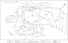
 ), 王亚楠2, 韩智颖2, 姚秀田3, 夏建2, 陈雨茂2, 李伟忠4